


Dhanushkodi, a town located on the southeastern tip of Pamban Island in Tamil Nadu, India, is often referred to as a ghost town. Its name, translating to “end of the bow,” is derived from a legend involving Lord Rama. According to the Ramayana, this is where Lord Rama built the Ram Setu bridge, also known as Adam’s Bridge, to reach Lanka and rescue Sita. The town was once a bustling port city, but today it is known for its ruins and haunting beauty.
Why is it called a Ghost Town?
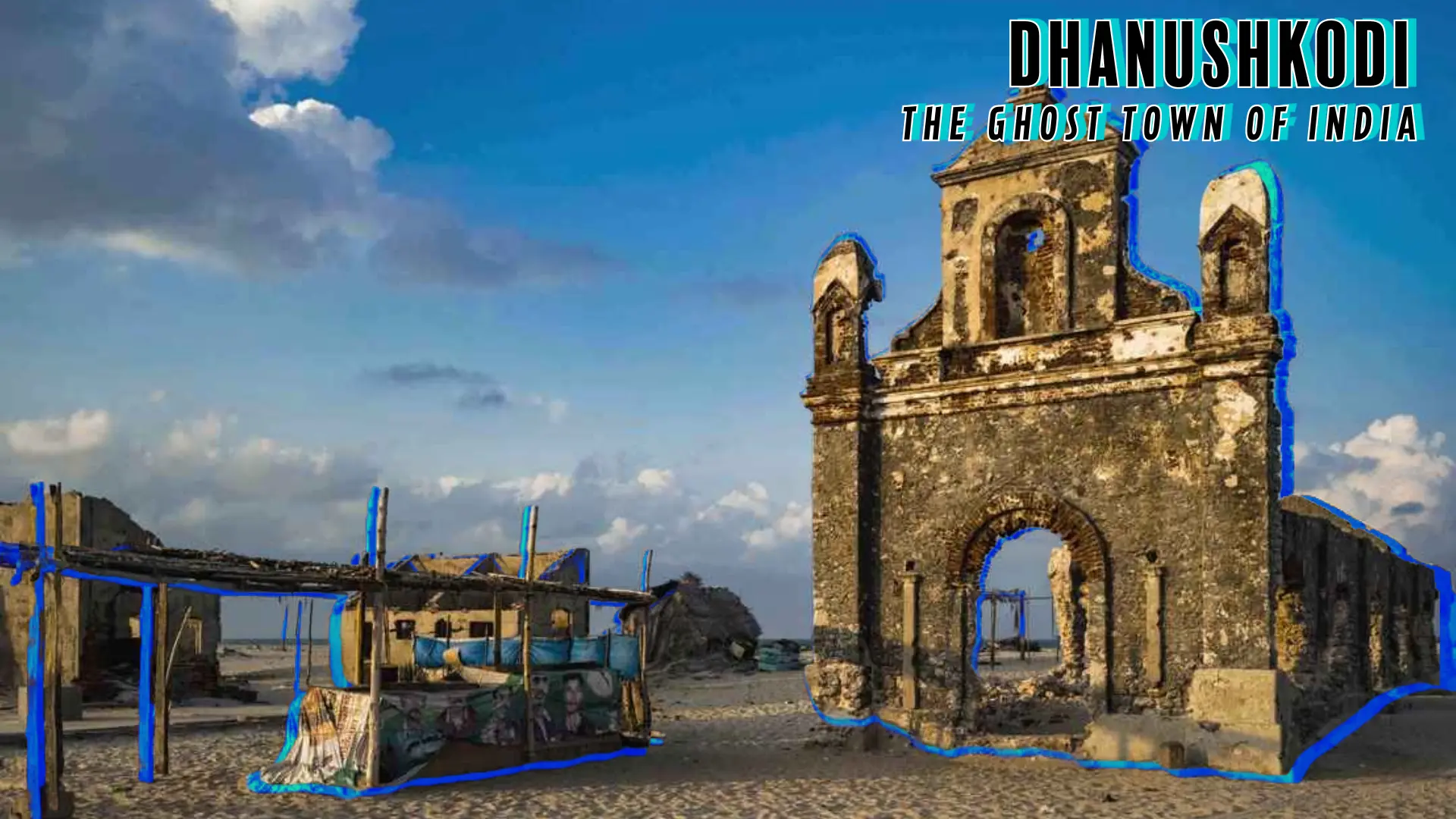
The title of ‘ghost town’ comes from a devastating cyclone that struck sidenote: Here are some additional points about Dhanushkodi: - **Mythological Significance:** The blog post mentions the Ramayana legend but could expand on this. - Dhanushkodi translates to "end of the bow," referencing Lord Rama using his bow to mark the spot for the Ram Setu bridge. - The Ram Setu bridge, also known as Adam’s Bridge, is said to be faintly visible from Dhanushkodi and has been confirmed by geologists. - Some believe that a floating rock kept in a Dhanushkodi temple was used in constructing the Ram Setu. - The pilgrimage to Kashi is considered complete only after bathing in the confluence at Dhanushkodi and performing ‘abhishek’ at Rameswaram Temple. - **Geographical Uniqueness**: - Dhanushkodi is located at the southeastern tip of Pamban Island, where the Bay of Bengal and the Indian Ocean meet. This confluence creates a visually striking contrast between the choppy Indian Ocean and the calmer Bay of Bengal. - The area is known for its reefs, shoals and sandbanks. - The southernmost tip of the island is called Arichal Munai, meaning "erosion point". - Dhanushkodi is about 24 kilometres (15 mi) west of Talaimannar in Sri Lanka. On a clear night, the Sri Lankan coast is visible from Dhanushkodi, which is about 30 km away. - **The 1964 Cyclone**: - The cyclone formed in the South Andaman Sea and moved westwards, crossing Sri Lanka before making landfall at Dhanushkodi on the night of December 22-23, 1964. - The estimated wind velocity was 280 kilometres per hour (170 mph), and tidal waves were 7 metres (23 ft) high. Other sources report waves as high as 20 feet. - The cyclone destroyed the metre-gauge railway line that connected Mandapam to Dhanushkodi. - A train carrying 115 passengers and 5 railway employees was engulfed by the waves. - The southern part of Dhanushkodi had subsided by almost 5 metres (16 ft) in 1948 and 1949, which contributed to the devastation. A 0.5 kilometer-wide strip of land was submerged by the sea. - The government of Madras declared Dhanushkodi a ghost town and unfit for living after the cyclone. - **Current Situation:** - Although officially a ghost town, a few fishermen and local shopkeepers reside there. - The population is around 500 people. - The people in Dhanushkodi face a tough life as there is no agriculture, limited water, and limited supplies. - The Tamil Nadu government provides basic supplies to the residents. - There are no schools, hospitals, or electricity in Dhanushkodi. - The town has become a tourist attraction because of its historical and mythological relevance. - Entry to the town is prohibited after 5 pm. - **Accessibility:** - Until 2016, Dhanushkodi was reachable by foot along the seashore or by jeep. - A road was completed in 2016 from Mukundarayar Chathiram, making it accessible by car. - The road is an extension of National Highway 87. - The final stretch is controlled by the Border Security Force. - You can reach Dhanushkodi from Rameshwaram by bus, auto rickshaw, taxi, or jeep. - The closest airport is Madurai Airport, which is 163 km away from Rameshwaram. - **Things to do** - Visitors can explore the ruins of the church, police station, and railway station. - They can also visit the Kothandaramaswamy Temple, which is dedicated to Lord Ram. - Swimming at the seashore is an activity, but it is not advised to go too far out into the sea. - The Gulf of Mannar Marine National Park is nearby. - **Other Points:** _ The sea receded about 500 meters from the coast in 2004, exposing parts of the submerged town before a tsunami struck the coast. _ The best time to visit is between October and February. _ It is recommended to start early for Dhanushkodi, before 7 am, and leave before 5 pm. _ It's advisable to bring packed food as there are no cafes or eateries in Dhanushkodi. in 1964. Before the cyclone, Dhanushkodi was a thriving town with a railway station, police station, medical centre, and other amenities. Ferries connected Dhanushkodi with Talaimannar in Sri Lanka and Chennai, making it a popular tourist destination. However, on December 22, 1964, a severe cyclonic storm with winds of 280 kilometres per hour and tidal waves as high as 7 metres (23 feet) battered the town. The cyclone completely destroyed Dhanushkodi, washing away buildings and a passenger train carrying 115 people. The government declared Dhanushkodi unfit for living after the disaster, leading to its abandonment.
What Actually Happened?
The cyclone of 1964 was a major catastrophe for Dhanushkodi. The storm formed in the South Andaman Sea and moved westwards, crossing Sri Lanka before making landfall at Dhanushkodi on the night of December 22-23. The high-speed winds and massive tidal waves caused widespread destruction. The southern part of Dhanushkodi had already experienced land subsidence, sinking by almost 5 metres in 1948 and 1949. The 1964 cyclone submerged a 0.5 kilometre-wide strip of land stretching 7 kilometers from north to south, adding to the devastation. An estimated 1,800 people died in the cyclone, including the passengers on the Pamban-Dhanushkodi passenger train.
The cyclone’s impact was so severe that it left the town in ruins. The town was marooned, and the government declared it a ghost town. While the town remains uninhabited by most, a few fishermen and local shopkeepers now call Dhanushkodi home.
Dhanushkodi Today:
Despite its tragic history, Dhanushkodi remains a tourist attraction. Visitors come to see the ruins, including the remains of the church, police station, and railway station. The confluence of the Bay of Bengal and the Indian Ocean is a striking sight, offering dramatic views. Other popular activities include visiting the Kothandaramaswamy Temple, which survived the cyclone, and exploring the Gulf of Mannar Marine National Park.
While the town was only reachable by foot or jeep until 2016, there is now a road from Mukundarayar Chathiram, making it easier to access. The area is still under the control of the Border Security Force, and entry is only permitted from 6 am to 5 pm.
Dhanushkodi is a place of both historical and mythological significance. It serves as a reminder of the destructive power of nature, while also offering a glimpse into the past and an appreciation of the beauty of the natural landscape. The haunting ruins and the stories of the past create an unforgettable experience for visitors.


Comments and Reactions